Home > Africa > Morocco > Maps
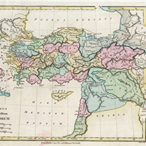
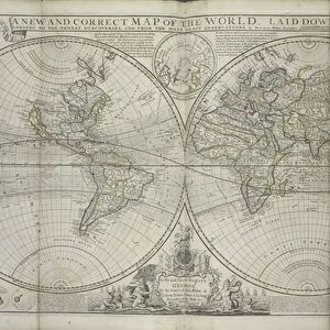
The Turkish Empire in Europe, Asia and Africa, 1736 (hand coloured print)
")
![]()
Wall Art and Photo Gifts from Fine Art Finder
The Turkish Empire in Europe, Asia and Africa, 1736 (hand coloured print)
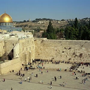
XOS1765727 The Turkish Empire in Europe, Asia and Africa, 1736 (hand coloured print) by Moll, Hermann (fl.1678-1732); 64x101 cm; New York Public Library, USA; (add.info.: The Turkish Empire in Europe, Asia and Africa, divided into all its governments, together with the other territories that are tributary to it, as also the dominions of ye Emperor of Marocco from The world described or A new and correct sett of maps shewing the kingdoms and states in all the known parts of the earth, with the principal cities, and most considerable towns in the world. Insets of Jerusalem and the Church of the Holy Sepulchre, also Constantinople and Smyrna.
Dedicated to the Honourable Thomas Vernon and published by Thomas Bowles, St Pauls Churchyard.); German, out of copyright
Media ID 12742647
© www.bridgemanimages.com
Constantinople Holy Sepulchre Istanbul Jerusalem Morocco Ottoman Ottoman Empire Vernon
FEATURES IN THESE COLLECTIONS
> Africa
> Morocco
> Related Images
> Africa
> Related Images
> Arts
> Artists
> B
> Thomas Bowles
> Arts
> Artists
> C
> Thomas Churchyard
> Arts
> Artists
> H
> Thomas Hand
> Asia
> Israel
> Jerusalem Heritage Sites
> Old City of Jerusalem and its Walls
> Asia
> Related Images
> Asia
> Turkey
> Related Images
> Fine Art Finder
> Artists
> Hermann Moll
> Fine Art Finder
> Maps (celestial & Terrestrial)
EDITORS COMMENTS
This hand-coloured print, titled "The Turkish Empire in Europe, Asia and Africa, 1736" takes us back to a time of great exploration and discovery. Created by the talented cartographer Hermann Moll, this map showcases the vast dominions of the Ottoman Empire along with other territories under its influence. Measuring an impressive 64x101 cm, this historic piece is housed in the New York Public Library's collection. It forms part of Moll's larger work entitled "The world described or A new and correct sett of maps shewing the kingdoms and states in all known parts of the earth". The intricate details on this print provide viewers with a comprehensive understanding of not only political boundaries but also important cities such as Jerusalem, Constantinople (now Istanbul), Smyrna (now Izmir), and even Morocco. With pictorial relief techniques employed throughout, this artwork offers a three-dimensional perspective that brings these regions to life. As we gaze upon it today, we are transported back to an era when empires reigned supreme and trade routes connected distant lands. Dedicated to Thomas Vernon and published by Thomas Bowles in St Pauls Churchyard, London; this print serves as both a historical document and a testament to Moll's skillful craftsmanship. Its presence reminds us of how cartography played an essential role in shaping our understanding of the world during times when exploration was at its peak.
MADE IN THE USA
Safe Shipping with 30 Day Money Back Guarantee
FREE PERSONALISATION*
We are proud to offer a range of customisation features including Personalised Captions, Color Filters and Picture Zoom Tools
SECURE PAYMENTS
We happily accept a wide range of payment options so you can pay for the things you need in the way that is most convenient for you
* Options may vary by product and licensing agreement. Zoomed Pictures can be adjusted in the Cart.