Home > Europe > United Kingdom > England > London > Towns > Isle of Dogs
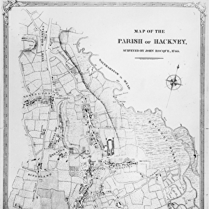
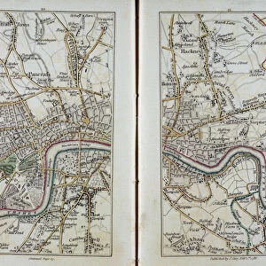
Map of East London, plates 20-21, from Carys Actual Survey of Middlesex

![]()
Wall Art and Photo Gifts from Fine Art Finder
Map of East London, plates 20-21, from Carys Actual Survey of Middlesex
XYC258622 Map of East London, plates 20-21, from Carys Actual Survey of Middlesex, 1786 (hand-coloured engraving) by Cary, John (c.1754-1835) (after); 15.2x21.1 cm; Yale Center for British Art, Paul Mellon Collection, USA; English, out of copyright
Media ID 12774241
© www.bridgemanart.com
Aerial View Bethnal Green Blackfriars Camberwell Hackney Hoxton Isle Of Dogs Islington Kentish Town Lambeth Limehouse Newington Peckham River Lea Roads Rotherhithe Southwark Stepney Stratford Survey Westminster
FEATURES IN THESE COLLECTIONS
> Europe
> United Kingdom
> England
> London
> Towns
> Isle of Dogs
> Fine Art Finder
> Artists
> John (after) Cary
> Fine Art Finder
> Maps (celestial & Terrestrial)
EDITORS COMMENTS
This print showcases the intricate details of a historical map titled "Map of East London, plates 20-21, from Cary's Actual Survey of Middlesex". Created in 1786 by John Cary, a renowned cartographer, this hand-colored engraving offers a fascinating glimpse into the past. The map measures 15.2x21.1 cm and is housed at the Yale Center for British Art as part of the esteemed Paul Mellon Collection. With its rich hues and meticulous craftsmanship, this Georgian-era map transports viewers to an era long gone. From Blackfriars to Westminster, Limehouse to Isle of Dogs, every street and road is meticulously depicted with precision. The aerial view provides a unique perspective on iconic landmarks such as Southwark Bridge and Hackney Marshes. As one explores this visual treasure trove further, lesser-known areas like Bethnal Green, Newington, Lambeth, Camberwell also come into focus. The inclusion of Rotherhithe and Stratford adds depth to our understanding of East London's history. Beyond its aesthetic appeal lies the invaluable historical significance embedded within these lines and symbols. This survey served as an essential tool for urban planning during that time period—guiding city officials in developing infrastructure and shaping communities. Through this print from Fine Art Finder courtesy of www. bridgemanart. com we are reminded not only of the beauty found in maps but also their role as windows into our collective pasts—a testament to human ingenuity in
MADE IN THE USA
Safe Shipping with 30 Day Money Back Guarantee
FREE PERSONALISATION*
We are proud to offer a range of customisation features including Personalised Captions, Color Filters and Picture Zoom Tools
SECURE PAYMENTS
We happily accept a wide range of payment options so you can pay for the things you need in the way that is most convenient for you
* Options may vary by product and licensing agreement. Zoomed Pictures can be adjusted in the Cart.