Home > Arts > Artists > H > Franz Hogenberg
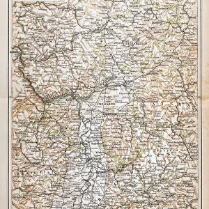
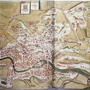
Map of Aachen (Aquisgranum), Germany (etching, 1572-1617)
, Germany (etching, 1572-1617)")
![]()
Wall Art and Photo Gifts from Fine Art Finder
Map of Aachen (Aquisgranum), Germany (etching, 1572-1617)
LRI4707776 Map of Aachen (Aquisgranum), Germany (etching, 1572-1617) by Hogenberg, Franz (1540-c.1590); Private Collection; (add.info.: Map of Aachen (Aquisgranum), Germany - Strong water extracted from Civitates Orbis Terrarum (Atlas of World Cities) by Georg Braun (1541-1622) and Franz Hogenberg (1540-1590), published from 1572 to 1617 - Aaachen or Bad Aachen, Germany - From " Civitates Orbis Terrarum" by G. Braun and F. Hogenberg, 1572-1617); Luisa Ricciarini; Netherlandish, out of copyright
Media ID 23327998
© Luisa Ricciarini / Bridgeman Images
Aix Chapel Atlas Book Blazon Coat Of Arm Exterior View Geographical Map
FEATURES IN THESE COLLECTIONS
> Animals
> Mammals
> Muridae
> Water Mouse
> Arts
> Artists
> H
> Franz Hogenberg
> Fine Art Finder
> Artists
> Franz Hogenberg
> Fine Art Finder
> Artists
> Unknown Artist
> Maps and Charts
> Related Images
> Maps and Charts
> World
EDITORS COMMENTS
This print showcases a remarkable etching of the "Map of Aachen (Aquisgranum), Germany" created by Franz Hogenberg between 1572 and 1617. The map, extracted from the renowned "Civitates Orbis Terrarum" atlas by Georg Braun and Franz Hogenberg, offers a fascinating glimpse into the city's rich history. Aachen, also known as Bad Aachen, is beautifully depicted in this engraving with its iconic Aix Chapel standing proudly in the foreground. The exterior view captures the essence of this historic German city, highlighting its architectural splendor and cultural significance. The intricate details on this map are truly awe-inspiring. From blazons to coats of arms adorning various buildings and landmarks, every element has been meticulously crafted to provide an accurate representation of Aachen during that era. As part of the larger atlas project spanning several decades, this particular piece holds immense historical value. It not only serves as a geographical guide but also provides insights into urban development and societal structures prevalent at that time. Luisa Ricciarini's expertly captured photograph allows us to appreciate the beauty and intricacy of this ancient map while preserving it for future generations to admire. Through her lens, we can delve into history and explore one corner of Germany's vibrant past encapsulated within these delicate lines engraved centuries ago.
MADE IN THE USA
Safe Shipping with 30 Day Money Back Guarantee
FREE PERSONALISATION*
We are proud to offer a range of customisation features including Personalised Captions, Color Filters and Picture Zoom Tools
SECURE PAYMENTS
We happily accept a wide range of payment options so you can pay for the things you need in the way that is most convenient for you
* Options may vary by product and licensing agreement. Zoomed Pictures can be adjusted in the Cart.