Home > Europe > France > Paris > Maps
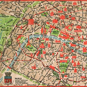
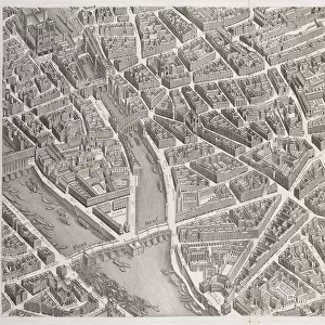
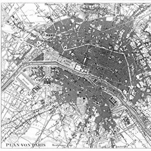
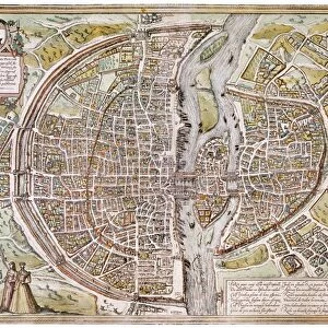
City map of Paris

![]()
Wall Art and Photo Gifts from Fine Art Storehouse
City map of Paris
Antique illustration of a City map of Paris
Unleash your creativity and transform your space into a visual masterpiece!
Nastasic
Media ID 13590469
© This content is subject to copyright
Antiquities City Map City Street Contour Drawing Downtown District French Culture Image Date Paris France Photography Themes Road Map Seine River Serbia Topography
FEATURES IN THESE COLLECTIONS
> Arts
> Contemporary art
> Photography
> Street art
> Arts
> Landscape paintings
> Waterfall and river artworks
> River artworks
> Arts
> Portraits
> Pop art gallery
> Street art portraits
> Europe
> France
> Paris
> Maps
> Europe
> France
> Paris
> Related Images
> Europe
> France
> Paris
> River Seine
> Europe
> Serbia
> Related Images
> Fine Art Storehouse
> The Magical World of Illustration
> Nastasic Images & Illustrations
> Fine Art Storehouse
> Map
> Historical Maps
EDITORS COMMENTS
This antique illustration of a City map of Paris takes us back in time to the enchanting streets and rich history of the French capital. The image, dating back to the 19th century, showcases the intricate details and artistry of an engraving technique. With its contour drawing and topographical features, this lithograph offers a glimpse into the old city's layout. The absence of people allows us to focus solely on the architectural marvels that define Paris. From grand boulevards to charming narrow streets, every corner seems to hold secrets waiting to be discovered. The meandering Seine River gracefully cuts through the heart of the city, adding a touch of serenity amidst bustling urban life. As we explore this ancient city map, we are transported not only geographically but also culturally. It is impossible not to feel immersed in French culture as we trace our fingers along these historic roads. Each street carries stories from centuries past, reminding us that Paris is more than just a place—it is a living testament to human creativity and resilience. This print by Nastasic captures both nostalgia for times gone by and admiration for enduring beauty. It serves as a reminder that even in our modern world, there is still much value in appreciating historical artifacts like this exquisite piece of cartography.
MADE IN THE USA
Safe Shipping with 30 Day Money Back Guarantee
FREE PERSONALISATION*
We are proud to offer a range of customisation features including Personalised Captions, Color Filters and Picture Zoom Tools
SECURE PAYMENTS
We happily accept a wide range of payment options so you can pay for the things you need in the way that is most convenient for you
* Options may vary by product and licensing agreement. Zoomed Pictures can be adjusted in the Cart.