Home > Fine Art Storehouse > The Magical World of Illustration > Palmer Illustrated Collection
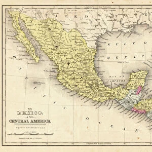
Mexico and Central America map 1869

![]()
Wall Art and Photo Gifts from Fine Art Storehouse
Mexico and Central America map 1869
Cornells Grammars-School Geography - S.S. Cornell - New York D. Appleton and Company 1869
Unleash your creativity and transform your space into a visual masterpiece!
THEPALMER
Media ID 13668823
© Roberto A Sanchez
Bay Of Water Central America Florida Us State Florida Usa Gulf Coast States Mexico South America The Americas Obsolete
FEATURES IN THESE COLLECTIONS
> Fine Art Storehouse
> The Magical World of Illustration
> Palmer Illustrated Collection
> Fine Art Storehouse
> Map
> Historical Maps
> Fine Art Storehouse
> Map
> USA Maps
EDITORS COMMENTS
This print showcases a remarkable piece of cartography from 1869, featuring the Mexico and Central America map. Taken from "Cornells Grammars-School Geography" by S. S. Cornell and published by D. Appleton and Company in New York, this engraved image provides a fascinating glimpse into the past. The map itself is an exquisite example of old-world craftsmanship, with intricate details meticulously etched onto its surface. Its physical geography highlights the diverse landscapes that make up this region, including Mexico, Central America, South America, and even parts of Florida in the United States. As we delve into this historical artifact, our eyes are drawn to the Bay of Water along the Gulf Coast states in Florida. The precise lines and labels on this horizontal illustration allow us to trace our fingers across borders and explore different territories within these continents. Although considered obsolete in terms of modern cartography techniques, this engraving holds immense value as a testament to how far we have come in understanding our world's geographical makeup. It serves as a reminder of how maps were once crafted with great care and artistry before digital technology revolutionized their creation. "The Mexico and Central America map 1869" transports us back to an era when exploration was still unfolding across these lands. Through THEPALMER's lens at Fine Art Storehouse, we can appreciate both its historical significance and aesthetic beauty captured within this timeless photograph print.
MADE IN THE USA
Safe Shipping with 30 Day Money Back Guarantee
FREE PERSONALISATION*
We are proud to offer a range of customisation features including Personalised Captions, Color Filters and Picture Zoom Tools
SECURE PAYMENTS
We happily accept a wide range of payment options so you can pay for the things you need in the way that is most convenient for you
* Options may vary by product and licensing agreement. Zoomed Pictures can be adjusted in the Cart.