Home > Europe > United Kingdom > England > London > Towns > Ealing
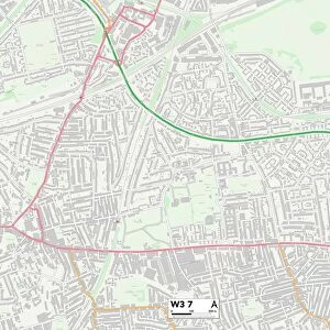
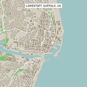
Ealing London UK City Street Map

![]()
Wall Art and Photo Gifts from Fine Art Storehouse
Ealing London UK City Street Map
Vector Illustration of a City Street Map of Ealing, London, UK. Included files are EPS (v10) and Hi-Res JPG.
Data courtesy from Ordnance Survey: VectorMap District
https:/ordnancesurvey.co.uk/business-and-government/products/vectormap-district.html
OS OpenData is free to use under the Open Government Licence (OGL).
Contains OS data eCrown copyright and database right 2017.
http:/nationalarchives.gov.uk/doc/open-government-licence/version/3/
Unleash your creativity and transform your space into a visual masterpiece!
Frank Ramspott
Media ID 15055203
© Frank Ramspott, all rights reserved
Aerial View Computer Graphic Directly Above Gray Green London Road Map Street Map Text Digitally Generated Image Ealing
FEATURES IN THESE COLLECTIONS
> Aerial Photography
> Related Images
> Arts
> Contemporary art
> Digital artwork
> Street art
> Arts
> Portraits
> Pop art gallery
> Street art portraits
> Arts
> Street art graffiti
> Digital art
> Digital paintings
> Arts
> Street art graffiti
> Digital art
> Vector illustrations
> Europe
> United Kingdom
> England
> London
> Boroughs
> Ealing
> Europe
> United Kingdom
> England
> London
> Towns
> Ealing
> Europe
> United Kingdom
> Maps
> Fine Art Storehouse
> Map
> Street Maps
> Maps and Charts
> Related Images
EDITORS COMMENTS
This print showcases a meticulously detailed city street map of Ealing, London, UK. The vector illustration captures the essence of this vibrant city with its intricate road network and architectural landmarks. Created by Frank Ramspott, this digitally generated image is a testament to his exceptional cartography skills. The map includes essential files in EPS (v10) format and a high-resolution JPG file, ensuring optimal quality for various purposes. The data used to create this masterpiece was graciously provided by Ordnance Survey: VectorMap District, an esteemed source known for its accuracy and reliability. It's worth noting that OS OpenData allows free usage under the Open Government Licence (OGL), emphasizing transparency and accessibility. However, it's important to acknowledge that the content contains OS data eCrown copyright and database right 2017 as per guidelines set by the National Archives. In this visually striking print, shades of gray seamlessly blend with hints of green and blue against a clean white backdrop. This aerial view perspective offers viewers a bird's-eye glimpse into Ealing's physical geography while highlighting key streets and buildings. Perfectly suited for both decorative or informational purposes, this stunning piece would make an excellent addition to any art collection or serve as an invaluable resource for those navigating through Ealing's bustling streetscape.
MADE IN THE USA
Safe Shipping with 30 Day Money Back Guarantee
FREE PERSONALISATION*
We are proud to offer a range of customisation features including Personalised Captions, Color Filters and Picture Zoom Tools
SECURE PAYMENTS
We happily accept a wide range of payment options so you can pay for the things you need in the way that is most convenient for you
* Options may vary by product and licensing agreement. Zoomed Pictures can be adjusted in the Cart.