Home > Aerial Photography > Related Images
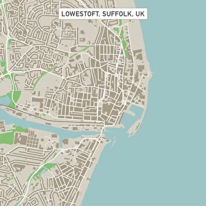
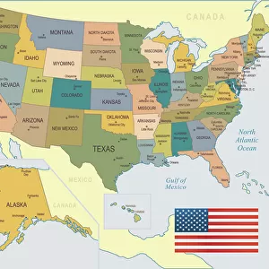
Spokane Washington US City Street Map

![]()
Wall Art and Photo Gifts from Fine Art Storehouse
Spokane Washington US City Street Map
Vector Illustration of a City Street Map of Spokane, Washington, USA. Scale 1:60, 000.
All source data is in the public domain.
U.S. Geological Survey, US Topo
Used Layers:
USGS The National Map: National Hydrography Dataset (NHD)
USGS The National Map: National Transportation Dataset (NTD)
Unleash your creativity and transform your space into a visual masterpiece!
Frank Ramspott
Media ID 15054991
© Frank Ramspott, all rights reserved
Aerial View City Map Computer Graphic Directly Above Downtown District Gray Road Map Text Washington State Digitally Generated Image Green Color Spokane Spokane River White Color
FEATURES IN THESE COLLECTIONS
> Aerial Photography
> Related Images
> Animals
> Insects
> Hemiptera
> Green Scale
> Arts
> Contemporary art
> Digital artwork
> Street art
> Arts
> Landscape paintings
> Waterfall and river artworks
> River artworks
> Arts
> Portraits
> Pop art gallery
> Street art portraits
> Arts
> Street art graffiti
> Digital art
> Digital paintings
> Arts
> Street art graffiti
> Digital art
> Vector illustrations
> Fine Art Storehouse
> Map
> Street Maps
> Fine Art Storehouse
> Map
> USA Maps
> Maps and Charts
> Geological Map
> Maps and Charts
> Related Images
> North America
> United States of America
> Lakes
> Related Images
EDITORS COMMENTS
This print showcases a detailed and intricate city street map of Spokane, Washington, USA. With a scale of 1:60,000, every nook and cranny of this vibrant city is beautifully illustrated in vector format. The artist, Frank Ramspott, has skillfully utilized various layers from the USGS The National Map to create this visually stunning piece. The map encompasses all the essential elements that define Spokane's identity - from its iconic Spokane River meandering through the downtown district to the serene lakes and bustling streets that shape its urban landscape. This digitally generated image offers an aerial view directly above the city, allowing viewers to immerse themselves in its physical geography. The color scheme chosen by Ramspott adds depth and clarity to the map. Shades of gray represent roads and streets while blue symbolizes water bodies such as rivers and lakes. White signifies open spaces while green denotes parks or natural areas within the city. With no people present in this composition, it solely focuses on showcasing Spokane's cartography with precision and artistry. This print serves as both an informative tool for navigation enthusiasts as well as a visually appealing work of art suitable for any space.
MADE IN THE USA
Safe Shipping with 30 Day Money Back Guarantee
FREE PERSONALISATION*
We are proud to offer a range of customisation features including Personalised Captions, Color Filters and Picture Zoom Tools
SECURE PAYMENTS
We happily accept a wide range of payment options so you can pay for the things you need in the way that is most convenient for you
* Options may vary by product and licensing agreement. Zoomed Pictures can be adjusted in the Cart.