Home > Aerial Photography > Related Images
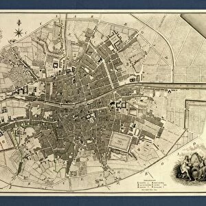
Wichita Kansas US City Street Map

![]()
Wall Art and Photo Gifts from Fine Art Storehouse
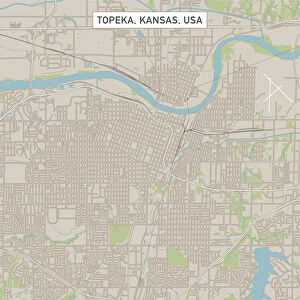
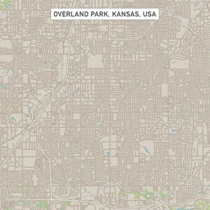
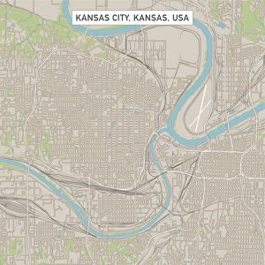
Wichita Kansas US City Street Map
Vector Illustration of a City Street Map of Wichita, Kansas, USA. Scale 1:60, 000.
All source data is in the public domain.
U.S. Geological Survey, US Topo
Used Layers:
USGS The National Map: National Hydrography Dataset (NHD)
USGS The National Map: National Transportation Dataset (NTD)
Unleash your creativity and transform your space into a visual masterpiece!
Frank Ramspott
Media ID 15215782
© Frank Ramspott, all rights reserved
Aerial View City Map Computer Graphic Directly Above Downtown District Gray Kansas Road Map Text Digitally Generated Image Green Color White Color Wichita
FEATURES IN THESE COLLECTIONS
> Aerial Photography
> Related Images
> Animals
> Insects
> Hemiptera
> Green Scale
> Arts
> Contemporary art
> Digital artwork
> Street art
> Arts
> Landscape paintings
> Waterfall and river artworks
> River artworks
> Arts
> Portraits
> Pop art gallery
> Street art portraits
> Arts
> Street art graffiti
> Digital art
> Digital paintings
> Arts
> Street art graffiti
> Digital art
> Vector illustrations
> Fine Art Storehouse
> Map
> Street Maps
> Fine Art Storehouse
> Map
> USA Maps
> Maps and Charts
> Geological Map
> Maps and Charts
> Related Images
> North America
> United States of America
> Kansas
> Kansas City
EDITORS COMMENTS
This print showcases a meticulously detailed vector illustration of Wichita, Kansas, USA. With a scale of 1:60,000, this city street map provides an intricate depiction of the downtown district along with its surrounding areas. The image encompasses various elements such as lakes, rivers, streets, and roads that form the backbone of this vibrant city. Created by Frank Ramspott using publicly available data from the U. S. Geological Survey's National Hydrography Dataset (NHD) and National Transportation Dataset (NTD), this digitally generated artwork is a testament to his exceptional cartography skills. The aerial view captured in this image offers a unique perspective directly above Wichita. The color palette used in this design adds depth and clarity to the map. Shades of gray represent urban areas while blue signifies water bodies like lakes and rivers. White color highlights roadways and green color denotes parks or open spaces within the city. Perfect for geography enthusiasts or those with an affinity for urban landscapes, this visually striking print effortlessly combines artistry with functionality. Whether displayed in homes or offices, it serves as both an aesthetically pleasing piece and a practical reference tool for navigating through Wichita's bustling streetscape
MADE IN THE USA
Safe Shipping with 30 Day Money Back Guarantee
FREE PERSONALISATION*
We are proud to offer a range of customisation features including Personalised Captions, Color Filters and Picture Zoom Tools
SECURE PAYMENTS
We happily accept a wide range of payment options so you can pay for the things you need in the way that is most convenient for you
* Options may vary by product and licensing agreement. Zoomed Pictures can be adjusted in the Cart.