Home > Europe > United Kingdom > England > London > Art > Theatre
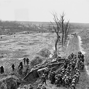
The Battles of the Flanders Ridges, July 30-November 26, 1917, (c1920). Creator: Unknown
. Creator: Unknown")
![]()
Wall Art and Photo Gifts from Heritage Images
The Battles of the Flanders Ridges, July 30-November 26, 1917, (c1920). Creator: Unknown
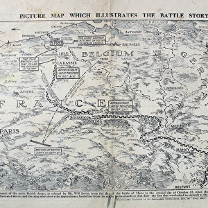
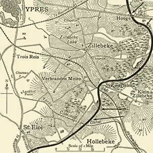
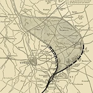
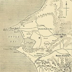
The Battles of the Flanders Ridges, July 30-November 26, 1917, (c1920)....map illustrating successive stages of the Allies advance...inset, key map showing the Flanders Front and the seaward end of the Allies lines on July 30, 1917. The Third Battle of Ypres, also known as the Battle of Passchendaele, took place on the Belgian Western Front from July to November 1917. It was fought between the British, Belgian and French armies against the Germans, and resulted in the deaths of hundreds of thousands of men. From " The Great World War: A History", Volume VII, edited by Frank A Mumby. [The Gresham Publishing Company Ltd, London, c1920]
Heritage Images features heritage image collections
Media ID 19665955
© The Print Collector/Heritage Images
Advance Allies Battle Of Passchendaele Frank A Frank A Mumby Frank Arthur Frank Arthur Mumby Front Line Frontline Gresham Publishing Co Ltd Gresham Publishing Company Keystone Archives Lines Mumby Mumby Frank A Mumby Frank Arthur Position Positions Ridge The Great World War A History Theatre Of War Third Battle Of Ypres Western Front Ypres Ypres Flanders Belgium Battlefield
FEATURES IN THESE COLLECTIONS
> Animals
> Mammals
> Muridae
> Western Mouse
> Europe
> Belgium
> Related Images
> Europe
> France
> Canton
> Allier
> Europe
> United Kingdom
> England
> London
> Art
> Theatre
> Historic
> Battles
> Related Images
EDITORS COMMENTS
This print titled "The Battles of the Flanders Ridges, July 30-November 26,1917" takes us back to the tumultuous era of the First World War. Created by an unknown artist around 1920, this map illustrates the successive stages of the Allies' advance during one of the most significant battles in history. Known as The Third Battle of Ypres or The Battle of Passchendaele, this fierce conflict unfolded on the Belgian Western Front from July to November 1917. It witnessed a relentless struggle between British, Belgian, and French forces against their German adversaries. Tragically, countless lives were lost during these months. Featured as an inset within this historical map is a key that highlights both the Flanders Front and the seaward end of the Allies' lines on July 30th, 1917. This visual aid provides valuable context for understanding how military positions evolved throughout this protracted battle. Taken from Volume VII of "The Great World War: A History" edited by Frank A Mumby and published by The Gresham Publishing Company Ltd in London circa 1920; this print offers a glimpse into one chapter among many in humanity's shared past. It serves as a poignant reminder not only of our capacity for destruction but also our resilience and determination amidst unimaginable adversity.
MADE IN THE USA
Safe Shipping with 30 Day Money Back Guarantee
FREE PERSONALISATION*
We are proud to offer a range of customisation features including Personalised Captions, Color Filters and Picture Zoom Tools
SECURE PAYMENTS
We happily accept a wide range of payment options so you can pay for the things you need in the way that is most convenient for you
* Options may vary by product and licensing agreement. Zoomed Pictures can be adjusted in the Cart.