Home > Europe > United Kingdom > England > London > Museums > British Library
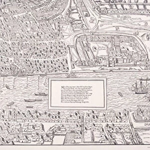
Map of the City of London, the River Thames, the City of Westminster and surrounding areas, 1700

![]()
Wall Art and Photo Gifts from Heritage Images
Map of the City of London, the River Thames, the City of Westminster and surrounding areas, 1700
Heritage Images features heritage image collections
Media ID 15175426
© London Metropolitan Archives (City of London) / Heritage-Images
Cartography Map Making City Of Westminster
FEATURES IN THESE COLLECTIONS
> Arts
> Minimalist artwork
> Monochrome artwork
> Fine art
> Arts
> Minimalist artwork
> Monochrome artwork
> Monochrome paintings
> Europe
> United Kingdom
> England
> London
> Boroughs
> City of London
> Europe
> United Kingdom
> England
> London
> Boroughs
> City of Westminster
> Europe
> United Kingdom
> England
> London
> Museums
> British Library
> Europe
> United Kingdom
> England
> London
> River Thames
> Europe
> United Kingdom
> England
> Maps
> Europe
> United Kingdom
> England
> Rivers
> Europe
> United Kingdom
> England
> Westminster
> Maps and Charts
> Related Images
EDITORS COMMENTS
This print showcases a remarkable piece of cartography from the 18th century. Titled "Map of the City of London, the River Thames, the City of Westminster and surrounding areas, 1700" it offers a fascinating glimpse into Britain's rich history. The intricate details captured in this engraving transport us back to an era when London was still evolving as a city. The map highlights not only the iconic landmarks such as Guildhall Library and Art Gallery but also provides insight into the geographical features that shaped this bustling metropolis. As we explore this monochrome masterpiece, we can't help but marvel at how much has changed over time. The river Thames takes center stage, serving as both a lifeline for trade and transportation while dividing these historic districts. The City of London stands proud with its winding streets and architectural wonders, while just across the river lies the majestic City of Westminster. Every inch of this map is meticulously crafted by C. Inselin, showcasing their skillful artistry in capturing every street corner and building facade with precision. It serves as a testament to English craftsmanship during that era. Whether you are an avid historian or simply captivated by British heritage, this print is sure to ignite your imagination and transport you back to 18th-century England—a true treasure for any lover of maps or admirer of old-world charm.
MADE IN THE USA
Safe Shipping with 30 Day Money Back Guarantee
FREE PERSONALISATION*
We are proud to offer a range of customisation features including Personalised Captions, Color Filters and Picture Zoom Tools
SECURE PAYMENTS
We happily accept a wide range of payment options so you can pay for the things you need in the way that is most convenient for you
* Options may vary by product and licensing agreement. Zoomed Pictures can be adjusted in the Cart.