Home > Arts > Artists > H > Jodocus Hondius
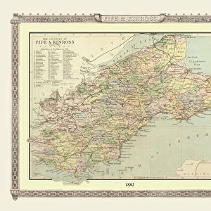
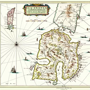
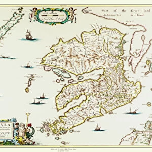
Old County Map of Fife 1654 by Johan Blaeu from the Atlas Novus

![]()
Wall Art and Photo Gifts from MapSeeker
Old County Map of Fife 1654 by Johan Blaeu from the Atlas Novus
This detailed and most attractive reproduction map of Fife has been carefully art worked from a scan of an antique original. The famous firm of Dutch cartographers and publishers was established in the late 16th century by Willem Janszoon Blaeu in Amsterdam. Blaeu was a maker of globes and scientific instruments and purchased some of his early map plates from Jodocus Hondius. From this small beginning was to emerge one of the largest and most prolific map publishing houses of the seventeenth century
Welcome to the Mapseeker Image library and enter an historic gateway to one of the largest on-line collections of Historic Maps, Nostalgic Views, Vista's and Panorama's from a World gone by.
Media ID 20347848
Blaeu Blaeu Family Blaue Map County Map County Map Of Scotland Johan Blaeu Johan Blaeu Map Old County Map Old Scottish County Map Scottish County Map Fife Fifeshire
FEATURES IN THESE COLLECTIONS
> Arts
> Artists
> B
> Willem Blaeu
> Arts
> Artists
> H
> Jodocus Hondius
> Arts
> Photorealistic artworks
> Detailed art pieces
> Masterful detailing in art
> Europe
> United Kingdom
> Scotland
> Fife
> Related Images
> Europe
> United Kingdom
> Scotland
> Maps
> Maps and Charts
> Early Maps
> Maps and Charts
> Willem Janszoon Blaeu
> MapSeeker
> Maps from the British Isles
> Scotland and Counties PORTFOLIO
EDITORS COMMENTS
This beautifully crafted print showcases an exquisite reproduction of the "Old County Map of Fife 1654" by Johan Blaeu, taken from the renowned Atlas Novus. Meticulously art worked from a scan of an antique original, this map captures the intricate details and allure of Fife's historical landscape. The Blaeu family, famous Dutch cartographers and publishers, established their firm in Amsterdam during the late 16th century. Willem Janszoon Blaeu, initially known for his globes and scientific instruments, acquired some map plates from Jodocus Hondius to kickstart his venture. Little did he know that this humble beginning would pave the way for one of the largest and most prolific map publishing houses in seventeenth-century Europe. With its rich history and cultural significance, Fife holds a special place within Scotland's heritage. This old Scottish county map offers a captivating glimpse into Fife's past, allowing us to trace its evolution over time. Whether you are a history enthusiast or simply appreciate fine craftsmanship, this historic Fife map is sure to captivate your imagination. Transport yourself back in time as you explore every nook and cranny of fifeshire through this meticulously reproduced piece. Discover ancient landmarks, follow winding rivers, and imagine what life was like centuries ago in this enchanting region. A true collector's item for those who cherish both history and cartography alike!
MADE IN THE USA
Safe Shipping with 30 Day Money Back Guarantee
FREE PERSONALISATION*
We are proud to offer a range of customisation features including Personalised Captions, Color Filters and Picture Zoom Tools
SECURE PAYMENTS
We happily accept a wide range of payment options so you can pay for the things you need in the way that is most convenient for you
* Options may vary by product and licensing agreement. Zoomed Pictures can be adjusted in the Cart.