Home > Maps and Charts > Related Images
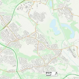
Bournemouth BH5 2 Map

![]()
Wall Art and Photo Gifts from Map Marketing
Bournemouth BH5 2 Map
Postcode Sector Map of Bournemouth BH5 2
Media ID 19966076
Ashbourne Road Beechwood Gardens Bournemouth College Road Colville Road Cromwell Place Cromwell Road Deans Road Dingle Road Granville Road Harcourt Road Harvey Road Livingstone Road Montague Road Morley Close Morley Road Parkwood Road Rotherfield Road Southville Road Warwick Place Wentworth Avenue Wentworth Close West Road Woodland Avenue Woodside Road St Jamess Square
FEATURES IN THESE COLLECTIONS
> Map Marketing
> Postcode Sector Maps
> BH - Bournemouth
> Maps and Charts
> Related Images
MADE IN THE USA
Safe Shipping with 30 Day Money Back Guarantee
FREE PERSONALISATION*
We are proud to offer a range of customisation features including Personalised Captions, Color Filters and Picture Zoom Tools
SECURE PAYMENTS
We happily accept a wide range of payment options so you can pay for the things you need in the way that is most convenient for you
* Options may vary by product and licensing agreement. Zoomed Pictures can be adjusted in the Cart.