Home > North America > United States of America > Indiana > Indianapolis
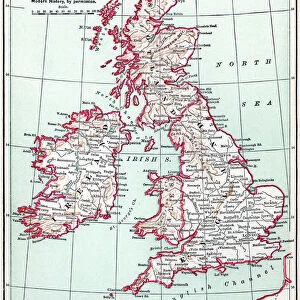
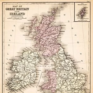
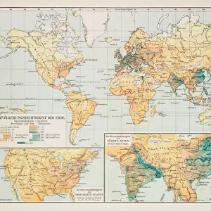
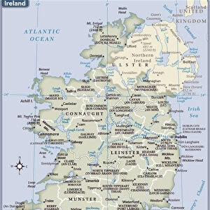
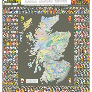
Map of the British isles 1889

![]()
Wall Art and Photo Gifts from Fine Art Storehouse
Map of the British isles 1889
Indiana Educational Series The Complete Geography - Indianapolis 1889
Unleash your creativity and transform your space into a visual masterpiece!
THEPALMER
Media ID 14756328
© This content is subject to copyright
Great Britain Ireland Scotland
FEATURES IN THESE COLLECTIONS
> Europe
> Republic of Ireland
> Maps
> Europe
> United Kingdom
> Maps
> Europe
> United Kingdom
> Scotland
> Maps
> Europe
> United Kingdom
> Scotland
> Posters
> Europe
> United Kingdom
> Scotland
> Related Images
> Fine Art Storehouse
> Map
> Historical Maps
> Maps and Charts
> Related Images
> North America
> United States of America
> Indiana
> Indianapolis
EDITORS COMMENTS
This print showcases a historical treasure, the "Map of the British Isles 1889" from Indiana Educational Series The Complete Geography - Indianapolis 1889. Crafted by THEPALMER, this exquisite piece takes us on a journey back in time to explore the intricate details of Great Britain, Ireland, Scotland, and the United Kingdom as they were over a century ago. The map's rich hues and meticulous cartography capture our attention immediately. It serves as both an educational tool and a work of art that transports us to an era when exploration was at its peak. Every contour line and geographic feature is intricately depicted with precision and care. As we delve into this visual masterpiece, we are reminded of how geography shapes history. This map provides invaluable insights into the political boundaries, topographical features, cities, towns, rivers, and coastlines that defined these lands during one of Britain's most transformative periods. THEPALMER has masterfully preserved this historical gem through their expert photography skills. The level of detail captured in every inch allows us to appreciate not only the craftsmanship behind this antique map but also its significance in understanding past societies. Whether you're an avid historian or simply fascinated by maps' ability to transport us across time and space, this print is sure to captivate your imagination while offering a glimpse into British Isles' complex past.
MADE IN THE USA
Safe Shipping with 30 Day Money Back Guarantee
FREE PERSONALISATION*
We are proud to offer a range of customisation features including Personalised Captions, Color Filters and Picture Zoom Tools
SECURE PAYMENTS
We happily accept a wide range of payment options so you can pay for the things you need in the way that is most convenient for you
* Options may vary by product and licensing agreement. Zoomed Pictures can be adjusted in the Cart.