Home > Europe > United Kingdom > Scotland > Edinburgh > Edinburgh
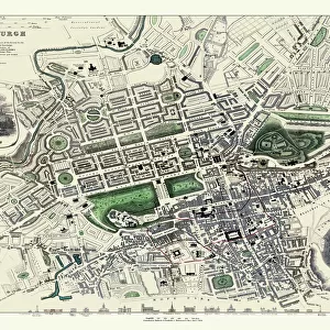
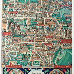
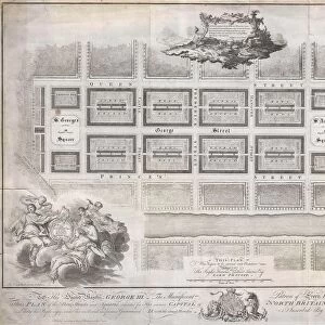
Old Map of Edinburgh Scotland 1851 by John Tallis

![]()
Wall Art and Photo Gifts from MapSeeker
Old Map of Edinburgh Scotland 1851 by John Tallis
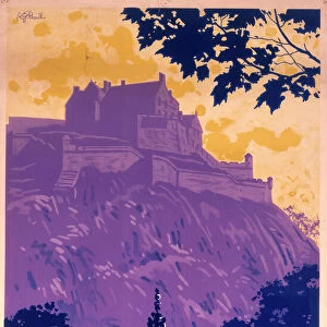
This Victorian map of Edinburgh in Scotland by John Tallis is dominated with a view to the top right across Edinburgh from the north- west towards Edinburgh Castle. Other illustrations are of the General Assembly Hall, Scotts Monument, Royal Institution, Royal High school and Burns Monument, Holyrood House and Arthurs Seat
Welcome to the Mapseeker Image library and enter an historic gateway to one of the largest on-line collections of Historic Maps, Nostalgic Views, Vista's and Panorama's from a World gone by.
Media ID 20348168
Edinburgh Historic Map John Tallis John Tallis Map Old Town Plan Tallis Map Edinburgh City
FEATURES IN THESE COLLECTIONS
> Arts
> Artists
> S
> John Scott
> Arts
> Artists
> T
> John Tallis
> Europe
> United Kingdom
> Heritage Sites
> Old and New Towns of Edinburgh
> Europe
> United Kingdom
> Scotland
> Castles
> Europe
> United Kingdom
> Scotland
> Edinburgh
> Edinburgh
> Europe
> United Kingdom
> Scotland
> Edinburgh
> Europe
> United Kingdom
> Scotland
> Lothian
> Edinburgh
> Europe
> United Kingdom
> Scotland
> Maps
> Historic
> Medieval architecture
> Castles and fortresses
> Historic castles
> Historic
> Monuments and landmarks
> Monuments and memorials
> MapSeeker
> British Town And City Plans
> Scottish PORTFOLIO
EDITORS COMMENTS
This print showcases an exquisite piece of history - the "Old Map of Edinburgh Scotland 1851" by John Tallis. Stepping back in time, this Victorian map transports us to a bygone era, offering a fascinating glimpse into the city's past. The focal point of the map is undoubtedly the majestic view from the northwest towards Edinburgh Castle, dominating the top right corner. The intricate details and artistic flair with which Tallis depicts this iconic landmark are truly remarkable. As our eyes wander across this vintage masterpiece, we discover other notable illustrations such as the General Assembly Hall, Scotts Monument, Royal Institution, Royal High School, Burns Monument, Holyrood House and Arthurs Seat. Every street and building on this town plan of Edinburgh tells a story; it unveils centuries-old secrets that lie within its walls. This historic map not only serves as a visual guide but also evokes a sense of nostalgia for those who have walked these streets before us. As we delve deeper into its intricacies and study each carefully etched line and symbol, we can almost hear echoes from another time whispering tales of Scottish heritage and culture. It reminds us that beneath modernity lies a rich tapestry woven with tradition and legacy. This print is more than just an old map; it is a gateway to rediscovering Edinburgh's past through John Tallis' skilled craftsmanship. A true treasure for history enthusiasts or anyone captivated by the allure of times gone by.
MADE IN THE USA
Safe Shipping with 30 Day Money Back Guarantee
FREE PERSONALISATION*
We are proud to offer a range of customisation features including Personalised Captions, Color Filters and Picture Zoom Tools
SECURE PAYMENTS
We happily accept a wide range of payment options so you can pay for the things you need in the way that is most convenient for you
* Options may vary by product and licensing agreement. Zoomed Pictures can be adjusted in the Cart.