Home > Europe > United Kingdom > Scotland > Strathclyde > Dumbarton
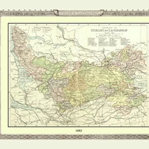
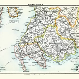
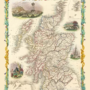
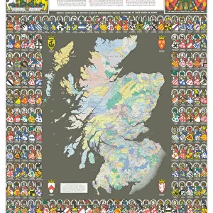
Old County Map of Dunbartonshire, formally called Dumbartonshire, Scotland 1847 by A&C Black

![]()
Wall Art and Photo Gifts from MapSeeker
Old County Map of Dunbartonshire, formally called Dumbartonshire, Scotland 1847 by A&C Black
A finely detailed facimile remastered in full colour from an antique original map of " Dumbartonshire" featured in A&C Blacks Atlas of 1847. Each Parish is numbered using an index table, colour rendition beautifully differentiating all of the Parishes. As well as principal roads, towns, villages and hamlets, these county maps of Scotland feature key battle sites marked with two crossed swords and the date of the battle. Dumbarton comes from the Scottish Gaelic Dšn Breatainn meaning " fort of the Britons".... Dumbartonshire County Council, set up under the Local Government (Scotland) Act 1889, adopted the spelling " Dunbartonshire" by 1914, a fact recognised by the Local Government (Scotland) Act 1947
Welcome to the Mapseeker Image library and enter an historic gateway to one of the largest on-line collections of Historic Maps, Nostalgic Views, Vista's and Panorama's from a World gone by.
Media ID 20347644
© Mapseeker Publishing Ltd
A And C Black A And C Black Atlas A And C Black Map County Map County Map Of Scotland Historic Map Old County Map Old Scottish County Map Dumbarton Dumbartonshire Dunbartonshire
FEATURES IN THESE COLLECTIONS
> Arts
> Photorealistic artworks
> Detailed art pieces
> Masterful detailing in art
> Europe
> United Kingdom
> Scotland
> Dumbarton
> Europe
> United Kingdom
> Scotland
> Maps
> Europe
> United Kingdom
> Scotland
> Strathclyde
> Dumbarton
> Historic
> Battles
> Related Images
> Maps and Charts
> Early Maps
> Maps and Charts
> Related Images
> MapSeeker
> Maps from the British Isles
> Scotland and Counties PORTFOLIO
EDITORS COMMENTS
This beautifully remastered print showcases an old county map of Dunbartonshire, formerly known as Dumbartonshire, Scotland in 1847. Created by A&C Black for their Atlas of 1847, this full-color facsimile captures the intricate details of the original antique map. Each parish is numbered and easily identifiable through a color-coded index table, adding to the visual appeal of this historic piece. In addition to highlighting principal roads, towns, villages, and hamlets within Dunbartonshire County, this map goes above and beyond by featuring key battle sites marked with two crossed swords and their corresponding dates. This inclusion provides a fascinating glimpse into the region's rich history. The name "Dumbarton" originates from Scottish Gaelic meaning "fort of the Britons" reflecting its ancient significance as a stronghold. However, it is interesting to note that Dumbartonshire County Council later adopted the spelling "Dunbartonshire" under various local government acts. Whether you are a history enthusiast or simply appreciate cartographic artistry, this old county map offers a captivating window into Dunbartonshire's past. Its meticulous detail and vibrant colors make it an ideal addition to any collection or display focused on Scottish heritage or historical maps.
MADE IN THE USA
Safe Shipping with 30 Day Money Back Guarantee
FREE PERSONALISATION*
We are proud to offer a range of customisation features including Personalised Captions, Color Filters and Picture Zoom Tools
SECURE PAYMENTS
We happily accept a wide range of payment options so you can pay for the things you need in the way that is most convenient for you
* Options may vary by product and licensing agreement. Zoomed Pictures can be adjusted in the Cart.