Home > Arts > Landscape paintings > Forest and woodland scenes > Forest artwork
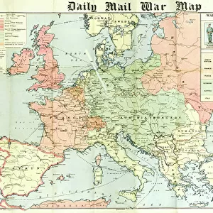
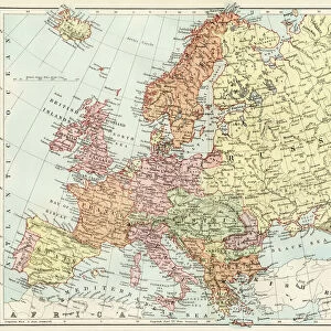
MAP / EUROPE / RUSSIA 1549

![]()
Wall Art and Photo Gifts from Mary Evans Picture Library
MAP / EUROPE / RUSSIA 1549
A map of Russia, concentrating on the areas surrounding Moscow. Date: 1549
Mary Evans Picture Library makes available wonderful images created for people to enjoy over the centuries
Media ID 20151649
© Bubblepunk
1549 Areas Concentrating Forests Maps Moscow Rivers Scale Shield Surrounding
FEATURES IN THESE COLLECTIONS
> Arts
> Landscape paintings
> Forest and woodland scenes
> Forest artwork
> Arts
> Landscape paintings
> Waterfall and river artworks
> River artworks
> Europe
> Related Images
> Europe
> Russia
> Related Images
> Maps and Charts
> Related Images
> Mary Evans Prints Online
> New Images July 2020
EDITORS COMMENTS
This intricately detailed map, titled "Russia, with the Provinces adjacent to Moskowa," dates back to the year 1549 and offers a captivating glimpse into the geographical knowledge of Europe during the Renaissance period. The map primarily focuses on the areas surrounding Moscow, the heart of the Russian Empire at the time. The map's border is adorned with ornate decorative shields, each bearing the emblems of various European countries, reflecting the interconnectedness of European and Russian political spheres. The map's scale is indicated at the bottom right, with the key to the map's symbols and legends situated at the bottom left. The map reveals the vast expanse of Russian territory, with the Volga River serving as a prominent feature, flowing from the northwest to the southeast. The forested regions, particularly along the northern and eastern borders, are meticulously depicted, providing insight into the dense and largely unexplored wilderness that surrounded Moscow. The map also highlights several important cities, including Kazan, Astrakhan, and Nizhny Novgorod, which were key trade centers and strategic strongholds in the Russian Empire. The border between Russia and its neighboring territories, such as Lithuania and Poland, is also clearly delineated, indicating the political tensions and complexities of the region during this time. Overall, this map provides a fascinating window into the geographical understanding of Europe and Russia during the 16th century, offering valuable insights into the political, economic, and cultural connections between these two distinct regions.
MADE IN THE USA
Safe Shipping with 30 Day Money Back Guarantee
FREE PERSONALISATION*
We are proud to offer a range of customisation features including Personalised Captions, Color Filters and Picture Zoom Tools
SECURE PAYMENTS
We happily accept a wide range of payment options so you can pay for the things you need in the way that is most convenient for you
* Options may vary by product and licensing agreement. Zoomed Pictures can be adjusted in the Cart.