Home > Europe > United Kingdom > England > London > Towns > Walworth
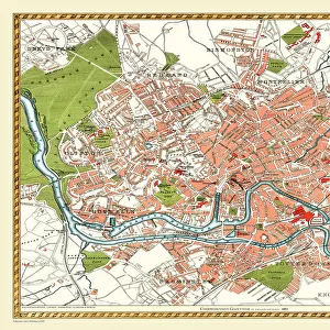
Old Street Map of London South and River Thames 1908

![]()
Wall Art and Photo Gifts from MapSeeker
Old Street Map of London South and River Thames 1908
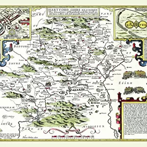
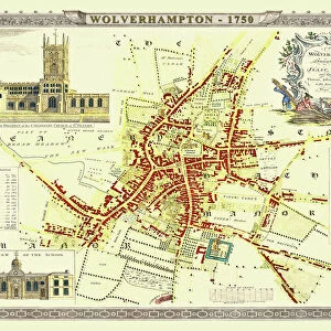
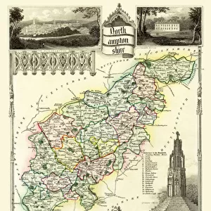
Detailed colour Street Plan of London from 1908. The street map features London South wiith the River Thames from Vauxhall Bridge to the London Docks and features Westminster, the Houses of Parliament. The area South of the Thames includes the London Boroughs of Lambeth, Walworth, Newington and Bermongsey
Welcome to the Mapseeker Image library and enter an historic gateway to one of the largest on-line collections of Historic Maps, Nostalgic Views, Vista's and Panorama's from a World gone by.
Media ID 20347791
© Mapseeker Publishing Ltd, Collins Bartholomew Ltd
London Street Plan Map Of Central London Old London Street Map Old Map Of London Central Street Plan Houses Of Parliament Lambeth Newington Walworth
FEATURES IN THESE COLLECTIONS
> Arts
> Photorealistic artworks
> Detailed art pieces
> Masterful detailing in art
> Europe
> United Kingdom
> England
> London
> Boroughs
> City of Westminster
> Europe
> United Kingdom
> England
> London
> Boroughs
> Lambeth
> Europe
> United Kingdom
> England
> London
> Boroughs
> Related Images
> Europe
> United Kingdom
> England
> London
> River Thames
> Europe
> United Kingdom
> England
> London
> Towns
> Lambeth
> Europe
> United Kingdom
> England
> London
> Towns
> Newington
> Europe
> United Kingdom
> England
> London
> Towns
> South Lambeth
> Europe
> United Kingdom
> England
> London
> Towns
> Vauxhall
> Europe
> United Kingdom
> England
> London
> Towns
> Walworth
> MapSeeker
> British Town And City Plans
> English & Welsh PORTFOLIO
EDITORS COMMENTS
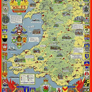
This print takes us back in time to the bustling streets of London in 1908. The old street map showcases the southern part of the city, including the majestic River Thames stretching from Vauxhall Bridge to the iconic London Docks. As we delve into this detailed color street plan, we are transported through history and immersed in a bygone era. The map highlights prominent landmarks such as Westminster and the Houses of Parliament, reminding us of London's rich political heritage. Venturing south of the river, we discover a tapestry of neighborhoods that make up this vibrant part of town: Lambeth, Walworth, Newington, and Bermongsey. Each borough holds its own unique charm and character. John Bartholomew's meticulous craftsmanship is evident throughout this historical piece. Every intricate detail has been carefully etched onto paper, capturing not only geographical accuracy but also an essence of life during that period. As we gaze upon this vintage treasure from MapSeeker Publishing's collection, our imagination runs wild with stories from long ago - horse-drawn carriages traversing cobbled streets, market vendors selling their wares along busy thoroughfares. This old street map serves as a portal to another time; it allows us to connect with our past while appreciating how far London has evolved over the years
MADE IN THE USA
Safe Shipping with 30 Day Money Back Guarantee
FREE PERSONALISATION*
We are proud to offer a range of customisation features including Personalised Captions, Color Filters and Picture Zoom Tools
SECURE PAYMENTS
We happily accept a wide range of payment options so you can pay for the things you need in the way that is most convenient for you
* Options may vary by product and licensing agreement. Zoomed Pictures can be adjusted in the Cart.