Home > Europe > United Kingdom > Wales > Railways
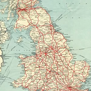
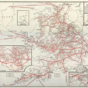
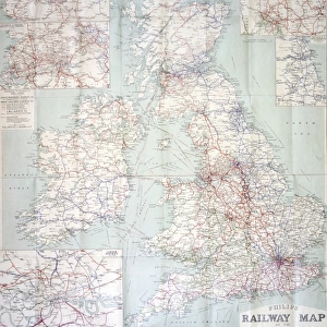
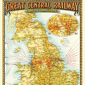
Old Map of the Routes and Stations of the Great Western Railway 1927

![]()
Wall Art and Photo Gifts from MapSeeker
Old Map of the Routes and Stations of the Great Western Railway 1927
Completely remastered from an original fold up map published in 1927, this reproduction map shows all the routes and stations of the Great Western Railway. To the top right a picture of an Express Passenger Locomotive " King George IV" bursting from a tunnel has been added; the map also shows sections in more detail of the districts of Birmingham and South Wales. The map also details the ferry crossing routes from mainland England and Wales
Welcome to the Mapseeker Image library and enter an historic gateway to one of the largest on-line collections of Historic Maps, Nostalgic Views, Vista's and Panorama's from a World gone by.
Media ID 20347410
© Mapseeker Publishing Ltd
Historic Railway Map Old Railway Map Railway Map
FEATURES IN THESE COLLECTIONS
> Architecture
> Tunnels
> Europe
> United Kingdom
> England
> Birmingham
> Related Images
> Europe
> United Kingdom
> England
> Maps
> Europe
> United Kingdom
> England
> Railways
> Europe
> United Kingdom
> Wales
> Maps
> Europe
> United Kingdom
> Wales
> Posters
> Europe
> United Kingdom
> Wales
> Railways
> Europe
> United Kingdom
> Wales
> Related Images
> Maps and Charts
> Related Images
> Maps and Charts
> Wales
> MapSeeker
> Old Railway and Canal Map Collection
> Old Railway Maps PORTFOLIO
EDITORS COMMENTS
This beautifully remastered print of the "Old Map of the Routes and Stations of the Great Western Railway 1927" takes us back in time to a bygone era of railway travel. Originally published as a fold-up map in 1927, this reproduction map showcases all the intricate routes and stations that made up the extensive Great Western Railway network. The attention to detail is truly remarkable, with sections dedicated to Birmingham and South Wales providing a closer look at these important districts. To add an extra touch of nostalgia, an image of the Express Passenger Locomotive "King George IV" bursts forth from a tunnel in the top right corner, capturing the power and majesty of steam locomotives that once ruled these tracks. One fascinating aspect highlighted on this map is the inclusion of ferry crossing routes from mainland England and Wales. This serves as a reminder that railways were not just confined to land but also played a crucial role in connecting different regions through water transport. MapSeeker Publishing Ltd has done an exceptional job preserving this historic railway map for future generations to appreciate. Whether you're a history enthusiast or simply captivated by vintage maps, this print offers both aesthetic appeal and valuable insights into one of Britain's most iconic railway networks – The Great Western Railway.
MADE IN THE USA
Safe Shipping with 30 Day Money Back Guarantee
FREE PERSONALISATION*
We are proud to offer a range of customisation features including Personalised Captions, Color Filters and Picture Zoom Tools
SECURE PAYMENTS
We happily accept a wide range of payment options so you can pay for the things you need in the way that is most convenient for you
* Options may vary by product and licensing agreement. Zoomed Pictures can be adjusted in the Cart.